Amerindian Tribes

Tobago was home to several Amerindian tribes before the arrival of Europeans. These tribes included the Arawaks, Caribs, and Waraos.

The Arawaks were the first known inhabitants of Tobago, and they arrived on the island around 500 AD. They were a peaceful people who lived off the land through fishing, hunting, and farming. They constructed homes made of wood and thatch, and their society was organized into clans and governed by a chief.

The Caribs, who were known for their aggressive nature, arrived on Tobago sometime in the 14th century, and they quickly established dominance over the Arawaks. They were skilled warriors and seafarers, and they used Tobago as a base for raiding nearby islands.

The Waraos, who were a seafaring people from the Orinoco Delta region of present-day Venezuela, also visited Tobago regularly for fishing and trading.

The arrival of European explorers and colonizers in the 16th century brought significant changes to Tobago’s indigenous population. The Spanish, French, Dutch, and British all established settlements on the island at various times, and they often used force to subjugate and exploit the native population. Many Amerindians were enslaved or forced to work on plantations, and their culture and way of life were eroded over time.

Today, there are few remaining traces of Tobago’s indigenous population, although some place names and archaeological sites serve as reminders of the island’s rich pre-colonial history. The Tobago Museum in Scarborough also has exhibits and information on the island’s indigenous peoples

Related Guides

  • |

    Hillsborough Reservoir

    Hillsborough Reservoir, which was commissioned in May 1952, by His Excellency Sir Hubert Elvin Rance, then Governor of Trinidad and Tobago, is the only impounding reservoir in Tobago.

    The reservoir is located 870 feet above sea level, Hillsborough has a rustic beauty and an elegantly designed spillway which provides a safety outlet when the reservoir is too full. The reservoir has a maximum storage capacity of 1.02 million m³ and the water treatment plant located just below can produce up to 9,091m3 per day.
    Water from the reservoir serves areas such as Mt. St. George, Concordia, Whim, Mary’s Hill, Union and Les Coteaux.

    The raw water from the reservoir passes through two strainers that clear the incoming water of large debris such as branches, twigs and leaves before entering the chemical house. Aluminium sulphate (alum) is added to make the suspended particles of silt and mud in the water coagulate and form large and heavier particles that sink to the bottom of the sedimentation (or settling) basins. The water is then filtered through layers of sand and gravel, a process that removes fine particles still in the water. The final stage of the water treatment process is the addition of lime, to counteract the acidity of the water and the injection of chlorine to destroy any disease-causing bacteria.

    Construction of the Hillsborough Dam significantly changed the landscape but the catchment area and the reservoir still teem with an abundance of wildlife and a variety of flora.
    There are twenty-eight (28) species of birds documented at Hillsborough which will excite the interest of any bird watcher.

    WASA

  • Districts of Tobago

    Tobago was previously divided into seven (7) parishes while under colonial rule. 

    • Saint Patrick
    • Saint Andrew
    • Saint David
    • Saint George
    • Saint Mary
    • Saint John
    • Saint Paul

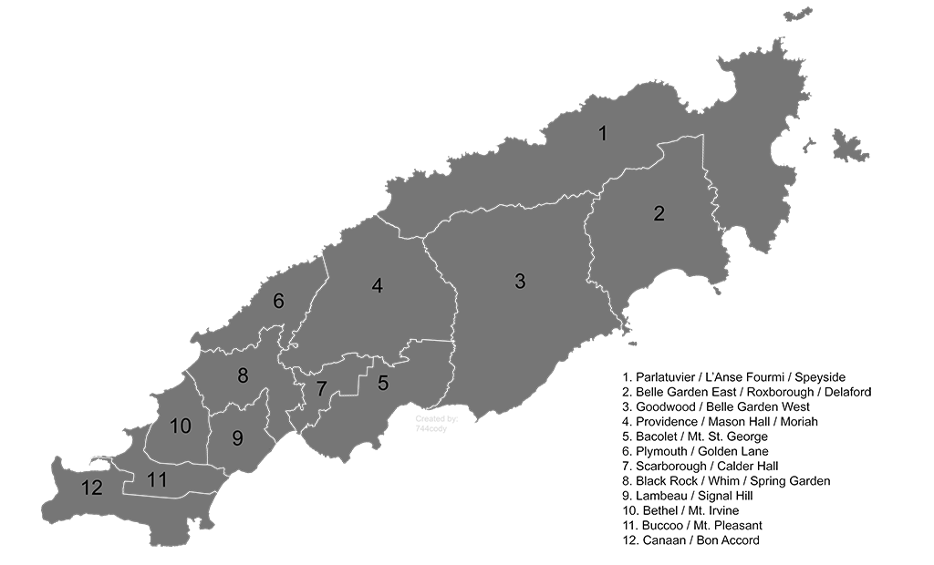
    In 1980 the Tobago House of Assembly replaced this system with twelve (12) local electorial districts and seats in the assembly.

    • Bacolet/Mt. Saint George
    • Goodwood/Belle Garden
    • Bethe/Mt. Irvine
    • Black Rock/Whim/Spring Garden
    • Buccoo/Mt. Pleasant
    • Canaan/Bon Accord
    • Lambeau/Signal Hill
    • Parlatuvier/L’Anse Fourmi/Speyside
    • Plymouth/Golden Lane
    • Providence/Mason Hall/Moriah
    • Belle Garden East/Roxborough/Deleford
    • Scarborough/Calder Hall

    In 2021 an additional 3 seat were added making it 15 electorial districts.

    Tobago is comprised of 15 electorial districts that are represented by seat in the Tobago House Of Assembly.
  • |

    Fort King George

    Fort King George is a historic fortification located on the island of Tobago in the Caribbean. It was built by the British in the late 18th century, during their colonial period in the region.

    The fort was constructed in 1779 on a hill overlooking the harbor of Scarborough, Tobago’s capital. Its primary purpose was to defend the island against French and Dutch attacks, as Tobago was a valuable strategic location in the Caribbean.

    Today, Fort King George is a popular tourist attraction and historical site. Visitors can explore the fort’s ruins, including the barracks, officer’s quarters, and cannons. There is also a small museum on the site that houses artifacts and exhibits related to Tobago’s history and the fort’s role in it.

    In addition to its historical significance, Fort King George offers spectacular views of the surrounding landscape, including the Caribbean Sea and the town of Scarborough. It is a must-visit destination for anyone interested in Caribbean history and architecture.

    Fort King George is named after King George III of Great Britain.
    The fort sits at the very top of Scarborough Hill (Fort Hill) with views of the Atlantic Ocean, Tobago’s capital town Scarborough and part of the south-eastern side of island.

    • Preserved buildings
    • Batteries
    • Cannons
    • Light house (old)
    • Manicured Garden
    • Museum
    • Views of Trinidad
  • Tobago

    Tobago is a beautiful Caribbean island located in the southern part of the Lesser Antilles. It is one of the two main islands that make up the Republic of Trinidad and Tobago, a country in the Caribbean Sea. Tobago is located about 30 kilometers northeast of Trinidad and covers an area of approximately 300 square kilometers.

    The island is known for its beautiful beaches, lush rainforests, and unique culture. The capital of Tobago is Scarborough, which is also the largest town on the island. The island is home to a population of approximately 60,000 people, and the official language is English.

    Tobago has a rich history and is known for its colonial heritage. It was once a Dutch, French, and British colony before gaining independence in 1962. Today, Tobago is a popular tourist destination known for its stunning beaches, vibrant coral reefs, and diverse wildlife.

    Some of the popular attractions on the island include Pigeon Point Beach, Store Bay, Buccoo Reef, and Nylon Pool. Tobago is also home to several festivals throughout the year, including the Tobago Heritage Festival, Carnival, Buccoo Goat Race, and the Great Fete Weekend.

    Tourism is the main industry on the island, and there are plenty of accommodation options ranging from luxury resorts to budget guesthouses. Some of the popular activities for visitors include hiking in the rainforest, bird watching, beach hopping, and visiting historical sites like Fort King George.

    The local culture is vibrant and colorful, with music, dance, and festivals playing an important role in daily life. Some of the most popular festivals include the Tobago Jazz Experience, the Tobago Heritage Festival, and the Great Fete Weekend.

    Overall, Tobago is a beautiful and welcoming island that offers visitors a unique blend of natural beauty, history, and culture. It is a great destination for anyone looking to experience the Caribbean in a more authentic and off-the-beaten-path way.

    • Capital – Scarborough
    • People – ~70,000
    • Islands – 6
    • Villages – 36+
    • Districts – 15
    • Towns – 2

    • Length – 25.5 miles
    • Size – 116 mi²
    • Width – 7.5 miles
    • Latitude – 11.2337° N 
    • Longitude – 60.6989° W
    • 21 miles North-East of Trinidad.

    Climate and Geography

    In terms of climate, Tobago has a tropical climate with temperatures ranging from 24°C to 32°C throughout the year. The rainy (wet) season runs from June to December, but even during this time, the island still experiences plenty of sunshine.

    Tobago’s climate is pleasant all year round. It is cooler and less humid than Trinidad because of the more frequent northeast winds.

    Government and Population

    Since 1889, Tobago and Trinidad have shared the same government. In 1980 the Tobago House of Assembly (THA) was instituted and was made responsible for administrative governance within the island, with local governance remaining with the city and county councils. In 1987, full internal self-governance was granted to Tobago. The population is approximately 70,000, of which 80 % are of African decent. 

    History

    Tobago has a rich history, with evidence of human habitation dating back over 5,000 years. The Amerindian Arawaks and the Carib tribes also inhabited the island, before it was colonized by Europeans in the 16th century and became a center of sugar production.

    Tobago changed hands several times between the British and the French, and it was also briefly occupied by the Dutch and Spanish. Today, Tobago is part of an independent nation, but it still retains strong ties to the United Kingdom.

  • | |

    Little Tobago

    Little Tobago is a small island located off the northeast coast of Tobago, which is itself an island in the southern Caribbean Sea and part of the nation of Trinidad and Tobago. Little Tobago is also known as Bird of Paradise Island, due to its abundance of exotic birds, including the red-billed tropicbird, the white-tailed sabrewing hummingbird, and the magnificent frigatebird.

    The island is home to a bird sanctuary and nature reserve, and is a popular destination for birdwatchers and eco-tourists. It is accessible by boat from the village of Speyside on Tobago’s main island.

    The island is popular for

    • Naturalists
    • Bird-watching
    • Angel reef
    • Scuba diving
    • Glass-bottom boat tours

    Angel reef is also a popular site around the island for divers and glass-bottom boat tours.

    The largest brain coral in the caribbean is also located on the reef system.

    The island is an important breeding site for seabirds such as red-billed tropicalbird, bridled terns and many more.

  • |

    Bon Accord Lagoon

    Bon Accord Lagoon is a shallow lagoon located on the southwestern coast of Tobago, which is an island in the southern Caribbean Sea and part of the nation of Trinidad and Tobago.

    The lagoon is separated from the ocean by a narrow strip of land, and is connected to the sea by a narrow channel. The area surrounding the lagoon is known for its mangrove forests and wetlands, which provide important habitat for a variety of bird species, including herons, egrets, and kingfishers.

    The lagoon is also home to a variety of fish, crabs, and other marine life. The area is popular for nature walks, birdwatching, and kayaking tours. Visitors can explore the lagoon and its surrounding mangrove forests on guided tours or by renting kayaks.

    The lagoon is located near the village of Bon Accord, which is accessible by car or taxi from the nearby Crown Point area.

    The Bon Accord Lagoon is surrounded by the mangrove wetlands and the Buccoo Reef making it an important habitat for many species of animals and marine life.

    The lagoon is easier to access by water with boats, kayaks, paddle-board etc.

    What’s near:

    • Buccoo Reef
    • No Man’s Land
    • Mangrove Wetlands
    • Pigeon Point
    • Buccoo Bay